Aerosol indirect effects - general circulation model intercomparison and evaluation with satellite data
ATMOS CHEM PHYS 9 (2009) 8697–8717-8697–8717
Abstract:
Aerosol indirect effects continue to constitute one of the most important uncertainties for anthropogenic climate perturbations. Within the international AEROCOM initiative, the representation of aerosol-cloud-radiation interactions in ten different general circulation models (GCMs) is evaluated using three satellite datasets. The focus is on stratiform liquid water clouds since most GCMs do not include ice nucleation effects, and none of the model explicitly parameterises aerosol effects on convective clouds. We compute statistical relationships between aerosol optical depth (tau(a)) and various cloud and radiation quantities in a manner that is consistent between the models and the satellite data. It is found that the model-simulated influence of aerosols on cloud droplet number concentration (N-d) compares relatively well to the satellite data at least over the ocean. The relationship between tau(a) and liquid water path is simulated much too strongly by the models. This suggests that the implementation of the second aerosol indirect effect mainly in terms of an autoconversion parameterisation has to be revisited in the GCMs. A positive relationship between total cloud fraction (f(cld)) and tau(a) as found in the satellite data is simulated by the majority of the models, albeit less strongly than that in the satellite data in most of them. In a discussion of the hypotheses proposed in the literature to explain the satellite-derived strong f(cld)-tau(a) relationship, our results indicate that none can be identified as a unique explanation. Relationships similar to the ones found in satellite data between tau(a) and cloud top temperature or outgoing long-wave radiation (OLR) are simulated by only a few GCMs. The GCMs that simulate a negative OLR-tau(a) relationship show a strong positive correlation between tau(a) and f(cld). The short-wave total aerosol radiative forcing as simulated by the GCMs is strongly influenced by the simulated anthropogenic fraction of tau(a), and parameterisation assumptions such as a lower bound on N-d. Nevertheless, the strengths of the statistical relationships are good predictors for the aerosol forcings in the models. An estimate of the total short-wave aerosol forcing inferred from the combination of these predictors for the modelled forcings with the satellite-derived statistical relationships yields a global annual mean value of -1.5 +/- 0.5 Wm(-2). In an alternative approach, the radiative flux perturbation due to anthropogenic aerosols can be broken down into a component over the cloud-free portion of the globe (approximately the aerosol direct effect) and a component over the cloudy portion of the globe (approximately the aerosol indirect effect). An estimate obtained by scaling these simulated clear- and cloudy-sky forcings with estimates of anthropogenic tau(a) and satellite-retrieved N-d-tau(a) regression slopes, respectively, yields a global, annual-mean aerosol direct effect estimate of -0.4 +/- 0.2 Wm(-2) and a cloudy-sky (aerosol indirect effect) estimate of -0.7 +/- 0.5 Wm(-2), with a total estimate of -1.2 +/- 0.4 Wm(-2).Automatic detection of ship tracks in ATSR-2 satellite imagery
ATMOS CHEM PHYS 9 (2009) 1899–1905-1899–1905
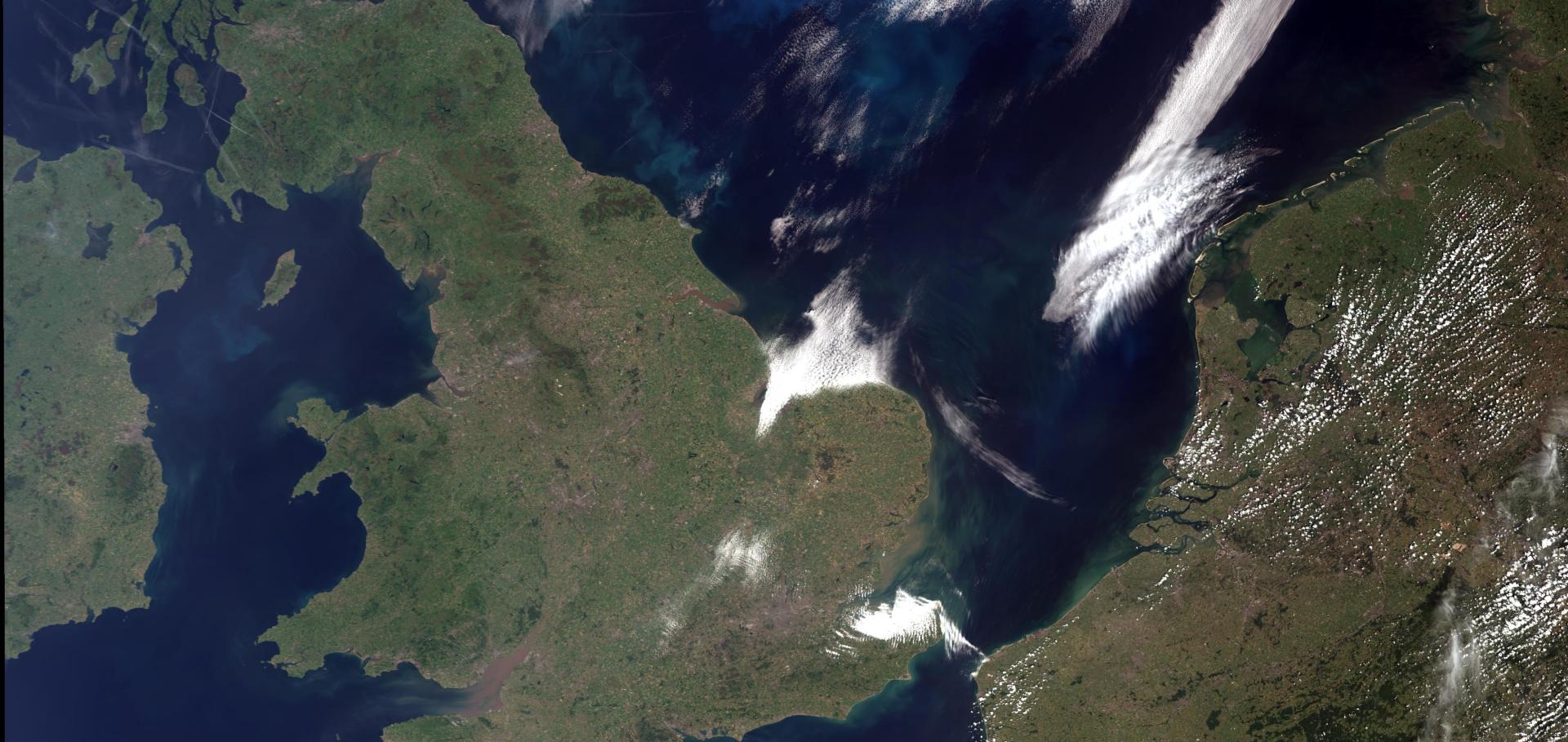
Abstract:
Ships modify cloud microphysics by adding cloud condensation nuclei (CCN) to a developing or existing cloud. These create lines of larger reflectance in cloud fields that are observed in satellite imagery. An algorithm has been developed to automate the detection of ship tracks in Along Track Scanning Radiometer 2 (ATSR-2) imagery. The scheme has been integrated into the Global Retrieval of ATSR Cloud Parameters and Evaluation (GRAPE) processing chain. The algorithm firstly identifies intensity ridgelets in clouds which have the potential to be part of a ship track. This identification is done by comparing each pixel with its surrounding ones. If the intensity of three adjacent pixels is greater than the intensity of their neighbours, then it is classified as a ridgelet. These ridgelets are then connected together, according to a set of connectivity rules, to form tracks which are classed as ship tracks if they are long enough. The algorithm has been applied to two years of ATSR-2 data. Ship tracks are most frequently seen off the west coast of California, and the Atlantic coast of both West Africa and South Western Europe. The global distribution of ship tracks shows strong seasonality, little inter-annual variability and a similar spatial pattern to the distribution of ship emissions.Automatic detection of ship tracks in ATSR-2 satellite imagery
ATMOSPHERIC CHEMISTRY AND PHYSICS 9:6 (2009) 1899-1905
Laboratory measurements of the optical properties of sea salt aerosol
ATMOS CHEM PHYS 9 (2009) 221–230-221–230
Abstract:
The extinction spectra of laboratory generated sea salt aerosols have been measured from 1 mu m to 20 mu m using a Bruker 66v/S FTIR spectrometer. Concomitant measurements include temperature, pressure, relative humidity and the aerosol size distribution. The refractive indices of the sea salt aerosol have been determined using a simple harmonic oscillator band model ( Thomas et al., 2004) for aerosol with relative humidities at eight different values between 0.4% to 86%. The resulting refractive index spectra show significant discrepancies when compared to existing sea salt refractive indices calculated using volume mixing rules (Shettle and Fenn, 1979). Specifically, an additional band is found in the refractive indices of dry sea salt aerosol and the new data shows increased values of refractive index at almost all wavelengths. This implies that the volume mixing rules, currently used to calculate the refractive indices of wet sea salt aerosols, are inadequate. Furthermore, the existing data for the real and imaginary parts of the refractive indices of dry sea salt aerosol are found not to display the Kramers-Kronig relationship. This implies that the original data used for the volume mixing calculations is also inaccurate.Optimal estimation retrieval of aerosol microphysical properties from SAGE II satellite observations in the lower stratosphere
Atmospheric Chemistry and Physics Discussions 9:6 (2009) 23719-23753