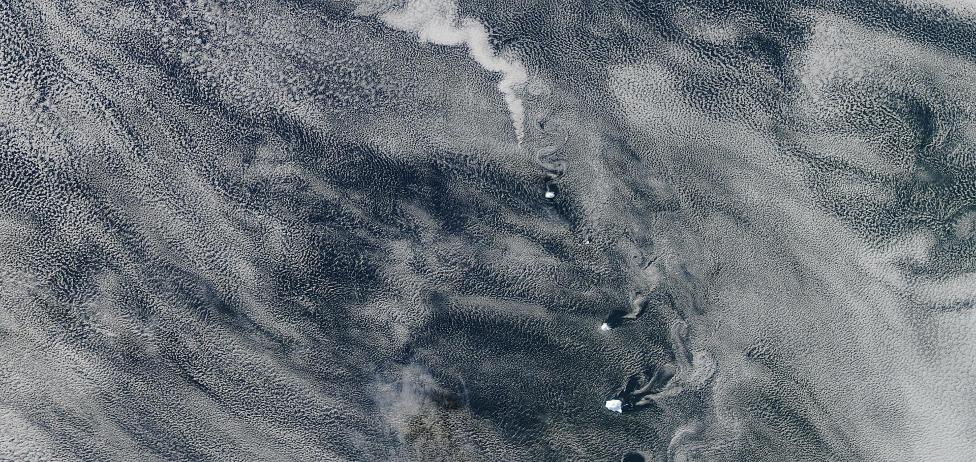
Shipping regulations lead to large reduction in cloud perturbations
Abstract:
Global shipping accounts for 13% of global emissions of SO2, which, once oxidized to sulfate aerosol, acts to cool the planet both directly by scattering sunlight and indirectly by increasing the albedo of clouds. This cooling due to sulfate aerosol offsets some of the warming effect of greenhouse gasses and is the largest uncertainty in determining the change in the Earth’s radiative balance by human activity. Ship tracks—the visible manifestation of the indirect of effect of ship emissions on clouds as quasi-linear features—have long provided an opportunity to quantify these effects. However, they have been arduous to catalog and typically studied only in particular regions for short periods of time. Using a machine-learning algorithm to automate their detection we catalog more than 1 million ship tracks to provide a global climatology. We use this to investigate the effect of stringent fuel regulations introduced by the International Maritime Organization in 2020 on their global prevalence since then, while accounting for the disruption in global commerce caused by COVID-19. We find a marked, but clearly nonlinear, decline in ship tracks globally: An 80% reduction in SO𝐱 emissions causes only a 25% reduction in the number of tracks detected.Robust evidence for reversal of the trend in aerosol effective climate forcing
Abstract:
Anthropogenic aerosols exert a cooling influence that offsets part of the greenhouse gas warming. Due to their short tropospheric lifetime of only several days, the aerosol forcing responds quickly to emissions. Here, we present and discuss the evolution of the aerosol forcing since 2000. There are multiple lines of evidence that allow us to robustly conclude that the anthropogenic aerosol effective radiative forcing (ERF) – both aerosol–radiation interactions (ERFari) and aerosol–cloud interactions (ERFaci) – has become less negative globally, i.e. the trend in aerosol effective radiative forcing changed sign from negative to positive. Bottom-up inventories show that anthropogenic primary aerosol and aerosol precursor emissions declined in most regions of the world; observations related to aerosol burden show declining trends, in particular of the fine-mode particles that make up most of the anthropogenic aerosols; satellite retrievals of cloud droplet numbers show trends in regions with aerosol declines that are consistent with these in sign, as do observations of top-of-atmosphere radiation. Climate model results, including a revised set that is constrained by observations of the ocean heat content evolution show a consistent sign and magnitude for a positive forcing relative to the year 2000 due to reduced aerosol effects. This reduction leads to an acceleration of the forcing of climate change, i.e. an increase in forcing by 0.1 to 0.3 W m−2, up to 12 % of the total climate forcing in 2019 compared to 1750 according to the Intergovernmental Panel on Climate Change (IPCC).Is anthropogenic global warming accelerating?
Abstract:
Estimates of the anthropogenic effective radiative forcing (ERF) trend have increased by 50% since 2000 (+0.4W/m2/decade in 2000-2009 to +0.6W/m2/decade in 2010-2019), the majority of which is driven by changes in the aerosol ERF trend, due to aerosol emissions reductions. Here we study the extent to which observations of the climate system agree with these ERF assumptions. We use a large ERF ensemble from IPCC’s Sixth Assessment Report (AR6) to attribute the anthropogenic contributions to global mean surface temperature (GMST), top-of-atmosphere radiative flux, and aerosol optical depth observations. The GMST trend has increased from +0.18°C/decade in 2000-2009 to +0.35°C/decade in 2010-2019, coinciding with the anthropogenic warming trend rising from +0.19°C/decade in 2000-2009 to +0.24°C/decade in 2010-2019. This, and observed trends in top-of-atmosphere radiative fluxes and aerosol optical depths support the claim of an aerosol-induced temporary acceleration in the rate of warming. However, all three observation datasets additionally suggest smaller aerosol ERF trend changes are compatible with observations since 2000, since radiative flux and GMST trends are significantly influenced by internal variability over this period. A zero-trend-change aerosol ERF scenario results in a much smaller anthropogenic warming acceleration since 2000, but is poorly represented in AR6’s ERF ensemble. Short-term ERF trends are difficult to verify using observations, so caution is required in predictions or policy judgments that depend on them, such as estimates of current anthropogenic warming trend, and the time remaining to, or the outstanding carbon budget consistent with, 1.5°C warming. Further systematic research focused on quantifying trends and early identification of acceleration or deceleration is required.Source attribution of cloud condensation nuclei and their impact on stratocumulus clouds and radiation in the south-eastern Atlantic
Abstract:
The semi-permanent stratocumulus clouds over the south-eastern Atlantic Ocean (SEA) can act as an “air conditioner” to the regional and global climate system. The interaction of aerosols and clouds becomes important in this region and can lead to negative radiative effects, partially offsetting the positive radiative forcing of greenhouse gases. A key pathway by which aerosols affect cloud properties is by acting as cloud condensation nuclei (CCN). In this paper, we use the United Kingdom Earth System Model (UKESM1) to investigate the sources of CCN (from emissions and atmospheric processes) in the SEA as well as the response of the cloud droplet number concentration (CDNC), the cloud liquid water path (LWP), and radiative forcing to these sources during 2016 and 2017. Overall, free and upper troposphere nucleated aerosols are the dominant source of the boundary layer CCN concentration at 0.2 % supersaturation (CCN0.2 %), contributing an annual average of ∼ 41 % as they subside and entrain into the marine boundary layer, which is consistent with observations highlighting the important role of nucleation in the boundary layer CCN concentration. In terms of emission sources, anthropogenic emissions (from energy, industry, agriculture, etc.) contribute the most to the annual average CCN0.2 % in the marine boundary layer (∼ 26 %), followed by biomass burning (BB, ∼ 17 %). In the cloud layer, BB contributes about 34 % of the annual CCN0.2 %, midway between the contributions from aerosol nucleation (36 %) and anthropogenic sources (31 %). The contribution of aerosols from different sources to the CDNC is consistent with their contribution to CCN0.2 % within the marine boundary layer, with free and upper troposphere aerosol nucleation being the most important source of the CDNC overall. In terms of emission sources, anthropogenic sources are also the largest contributors to the annual average CDNC, closely followed by BB. However, during the BB season, BB and free and upper troposphere aerosol nucleation are equally the most important sources of the CDNC. The contribution of BB to the CDNC is more significant than its increase to CCN0.2 %, mainly because BB aerosols are mostly located directly above the inversion layer in the model; thus, they can increase the in-cloud CDNC by enhancing the supersaturation through the dynamical feedback due to short-wave absorption. An aerosol source that shows an increase in the CDNC also shows an increase in the LWP resulting from a reduction in autoconversion. Due to the absorption effect, BB aerosol can enhance existing temperature inversions and reduce the entrainment of sub-saturated air, leading to a further increase in the LWP. As a result, the contribution of BB to the LWP is second only to aerosol nucleation on annual averages. These findings demonstrate that BB is not the dominant source of CCN within the marine boundary layer from an emission source perspective. However, as most BB aerosols are located directly above the inversion layer, their effect on clouds increases due to their absorption effect (about the same as anthropogenic sources for the CDNC and more than anthropogenic sources for the LWP), highlighting the crucial role of their radiative effect on clouds. The results on the radiative effects of aerosols show that BB aerosol exhibits an overall positive RFari (radiative forcing associated with aerosol–radiation interactions), but its net effective radiative forcing remains negative due to its effect on clouds (mainly due to its absorbing effect). By quantifying aerosol and cloud properties affected by different sources, this paper provides a framework for understanding the effects of aerosol sources on marine stratocumulus clouds and radiation in the SEA.