Intraseasonal shift in the wintertime North Atlantic jet structure projected by CMIP6 models
npj Climate and Atmospheric Science Nature Research 7:1 (2024) 234
Abstract:
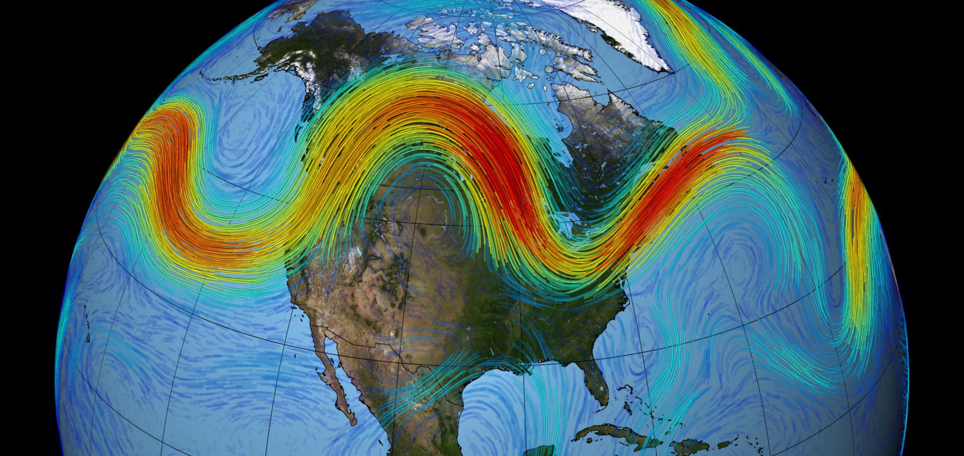
The projected winter changes of the North Atlantic eddy-driven jet (EDJ) under climate change conditions have been extensively analysed. Previous studies have reported a squeezed and elongated EDJ. However, other changes present large uncertainties, specifically those related to the intensity and latitude. Here, the projections of the EDJ in a multimodel ensemble of CMIP6 are scrutinised by using a multiparametric description of the EDJ. The multimodel mean projects non-stationary responses of the EDJ latitude through the winter, characterised by a poleward shift in early winter and equator migration in late winter. These intraseasonal shifts (rather than a genuine narrowing) explain the previously established squeezing of the EDJ and are linked to the future changes in different drivers: the 200 hPa meridional temperature gradient and Atlantic warming hole in early winter, and the stratospheric vortex in late winter. Model biases also influence EDJ projections, contributing to the poleward shift in early winter.JWST/NIRISS Reveals the Water-rich “Steam World” Atmosphere of GJ 9827 d
The Astrophysical Journal Letters American Astronomical Society 974:1 (2024) L10
Abstract:
With sizable volatile envelopes but smaller radii than the solar system ice giants, sub-Neptunes have been revealed as one of the most common types of planet in the galaxy. While the spectroscopic characterization of larger sub-Neptunes (2.5–4 R ⊕) has revealed hydrogen-dominated atmospheres, smaller sub-Neptunes (1.6–2.5 R ⊕) could either host thin, rapidly evaporating, hydrogen-rich atmospheres or be stable, metal-rich “water worlds” with high mean molecular weight atmospheres and a fundamentally different formation and evolutionary history. Here, we present the 0.6–2.8 μm JWST/NIRISS/SOSS transmission spectrum of GJ 9827 d, the smallest (1.98 R ⊕) warm (T eq,A=0.3 ∼ 620 K) sub-Neptune where atmospheric absorbers have been detected to date. Our two transit observations with NIRISS/SOSS, combined with the existing HST/WFC3 spectrum, enable us to break the clouds–metallicity degeneracy. We detect water in a highly metal-enriched “steam world” atmosphere (O/H of ∼4 by mass and H2O found to be the background gas with a volume mixing ratio of >31%). We further show that these results are robust to stellar contamination through the transit light source effect. We do not detect escaping metastable He, which, combined with previous nondetections of escaping He and H, supports the steam atmosphere scenario. In water-rich atmospheres, hydrogen loss driven by water photolysis happens predominantly in the ionized form, which eludes observational constraints. We also detect several flares in the NIRISS/SOSS light curves with far-UV energies of the order of 1030 erg, highlighting the active nature of the star. Further atmospheric characterization of GJ 9827 d probing carbon or sulfur species could reveal the origin of its high metal enrichment.Emerging signals of climate change from the equator to the poles: new insights into a warming world
Frontiers in Science Frontiers Media 2 (2024) 1340323
Abstract:
The reality of human-induced climate change is unequivocal and exerts an ever-increasing global impact. Access to the latest scientific information on current climate change and projection of future trends is important for planning adaptation measures and for informing international efforts to reduce emissions of greenhouse gases (GHGs). Identification of hazards and risks may be used to assess vulnerability, determine limits to adaptation, and enhance resilience to climate change. This article highlights how recent research programs are continuing to elucidate current processes and advance projections across major climate systems and identifies remaining knowledge gaps. Key findings include projected future increases in monsoon rainfall, resulting from a changing balance between the rainfall-reducing effect of aerosols and rainfall-increasing GHGs; a strengthening of the storm track in the North Atlantic; an increase in the fraction of precipitation that falls as rain at both poles; an increase in the frequency and severity of El Niño Southern Oscillation (ENSO) events, along with changes in ENSO teleconnections to North America and Europe; and an increase in the frequency of hazardous hot-humid extremes. These changes have the potential to increase risks to both human and natural systems. Nevertheless, these risks may be reduced via urgent, science-led adaptation and resilience measures and by reductions in GHGs.Drivers of the ECMWF SEAS5 seasonal forecast for the hot and dry European summer of 2022
Quarterly Journal of the Royal Meteorological Society Wiley (2024)